
Haz una donación
Equípate para tu próxima aventura:
Como asociado de Amazon, este sitio gana comisiones por las compras que califican, sin ningún costo adicional para usted.
Mapa topográfico Big Pine
Haga clic en el mapa para ver la altitud.
Haz una donación
Equípate para tu próxima aventura:
Como asociado de Amazon, este sitio gana comisiones por las compras que califican, sin ningún costo adicional para usted.
Big Pine
Big Pine (formerly, Bigpine) is a census-designated place (CDP) in Inyo County, California, United States. Big Pine is located approximately 15 miles (24 km) south-southeast of Bishop, at an elevation of 3,989 feet (1,216 m). The population was 1,756 at the 2010 census, up from 1,350 at the 2000 census. The Big Pine Band of Owens Valley Paiute Shoshone Indians of the Big Pine Reservation operates their tribal headquarters from here.
Haz una donación
Equípate para tu próxima aventura:
Como asociado de Amazon, este sitio gana comisiones por las compras que califican, sin ningún costo adicional para usted.
Acerca de este mapa
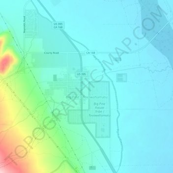
Nombre: Mapa topográfico Big Pine, altitud, relieve.
Lugar: Big Pine, Inyo County, California, 92513, United States (37.14283 -118.31490 37.18673 -118.27680)
Altitud media: 1.228 m
Altitud mínima: 1.192 m
Altitud máxima: 1.391 m
Haz una donación
Equípate para tu próxima aventura:
Como asociado de Amazon, este sitio gana comisiones por las compras que califican, sin ningún costo adicional para usted.
Otros mapas topográficos
Haga clic en un mapa para ver su topografía, su altitud y su relieve.