
Mapa topográfico Mattoon
Mapa interactivo
Haga clic en el mapa para ver la altitud.
Acerca de este mapa
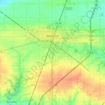
Nombre: Mapa topográfico Mattoon, altitud, relieve.
Lugar: Mattoon, Coles County, Illinois, 61938, United States (39.41045 -88.41922 39.52085 -88.26652)
Altitud media: 220 m
Altitud mínima: 201 m
Altitud máxima: 242 m
One of the main factors determining the settlement of Mattoon and Coles County in general was the topography. Coles County straddled a timberline in the southern half and prairie in the north. The forested areas were primarily fed by two major rivers: the Embarras River in the east and the Kaskaskia in the west. The prairie, known as the "Grand Prairie", was generally wet and swampy. An early historian described the geography:
Otros mapas topográficos
Haga clic en un mapa para ver su topografía, su altitud y su relieve.
Fox Ridge State Park
United States > Illinois > Coles County
Fox Ridge State Park, Coles County, Illinois, United States
Altitud media: 200 m
Charleston
United States > Illinois > Coles County
Charleston, Coles County, Illinois, 61920, United States
Altitud media: 205 m
Lerna
United States > Illinois > Coles County
Lerna, Coles County, Illinois, United States
Altitud media: 228 m