
Haz una donación
Equípate para tu próxima aventura:
Como asociado de Amazon, este sitio gana comisiones por las compras que califican, sin ningún costo adicional para usted.
Mapa topográfico Albenga
Haga clic en el mapa para ver la altitud.
Haz una donación
Equípate para tu próxima aventura:
Como asociado de Amazon, este sitio gana comisiones por las compras que califican, sin ningún costo adicional para usted.
Albenga
The current design is the result of further elevations. The restoration works between 1964 and 1967 brought back the cathedral design to its original medieval aspect. The nearby steeple was attached to the church in the 13th century, built over the ruins of the old bell tower between the years 1391 and 1395. This construction is one of the last local examples of the use of bare bricks, progressively replaced by plastering.
Haz una donación
Equípate para tu próxima aventura:
Como asociado de Amazon, este sitio gana comisiones por las compras que califican, sin ningún costo adicional para usted.
Acerca de este mapa
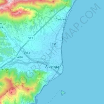
Nombre: Mapa topográfico Albenga, altitud, relieve.
Lugar: Albenga, Savona, Liguria, Italy (44.02287 8.09942 44.10121 8.22985)
Altitud media: 85 m
Altitud mínima: -1 m
Altitud máxima: 761 m
Haz una donación
Equípate para tu próxima aventura:
Como asociado de Amazon, este sitio gana comisiones por las compras que califican, sin ningún costo adicional para usted.