
Mapa topográfico Tehran
Mapa interactivo
Haga clic en el mapa para ver la altitud.
Acerca de este mapa
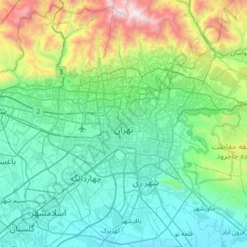
Nombre: Mapa topográfico Tehran, altitud, relieve.
Altitud media: 1.539 m
Altitud mínima: 976 m
Altitud máxima: 3.943 m
As the city has a large area, with significant differences in elevation among various districts, the weather is often cooler in the hilly north than in the flat southern part of Tehran. For instance, the 17.3 km (10.7 mi) Valiasr Street runs from Tehran's railway station at 1,117 m (3,665 ft) elevation above sea level in the south of the city to Tajrish Square at 1712.6 m (5612.3 ft) elevation above sea level in the north. However, the elevation can even rise up to 2,000 m (6,600 ft) at the end of Velenjak in northern Tehran. The sparse texture, the existence of old gardens, orchards, green spaces along the highways and the lack of industrial activities in the north of the city have helped the air in the northern areas to be 2 to 3 degrees Celsius cooler than the southern areas of the city.
Otros mapas topográficos
Haga clic en un mapa para ver su topografía, su altitud y su relieve.
District 5
Iran > Tehran County > Tehran
District 5, Tehran, بخش مرکزی شهرستان تهران, Tehran County, Tehran Province, Iran
Altitud media: 1.474 m
باغ انگلیسی پارک لاله
Iran > Tehran County > Tehran
باغ انگلیسی پارک لاله, ناحیه ۲, District 6, شهرداری منطقه شش ناحیه یک, Tehran, بخش مرکزی شهرستان تهران, Tehran County, Tehran Province, 14166-14178, Iran
Altitud media: 1.239 m
Talun
Iran > Tehran County > دهستان سولقان
Talun, دهستان سولقان, بخش کن, Tehran County, Tehran Province, Iran
Altitud media: 2.909 m
District 19
Iran > Tehran County > Tehran
District 19, Tehran, بخش مرکزی شهرستان تهران, Tehran County, Tehran Province, Iran
Altitud media: 1.102 m
Mellat Park
Iran > Tehran County > Tehran
Mellat Park, District 3, Tehran, بخش مرکزی شهرستان تهران, Tehran County, Iran
Altitud media: 1.528 m
رود فرحزاد
Iran > Tehran County > Tehran
رود فرحزاد, Punak, District 2, Tehran, بخش مرکزی شهرستان تهران, Tehran County, 14678-93963, Iran
Altitud media: 1.509 m
41
Iran > Tehran County > Tehran
41, شهرداری منطقه شش ناحیه یک, Tehran, بخش مرکزی شهرستان تهران, Tehran County, Tehran Province, 15989-35611, Iran
Altitud media: 1.226 m
Pardis
Iran > Tehran County > Tehran
Pardis, Zibadasht, District 22, Tehran, بخش مرکزی شهرستان تهران, Tehran County, Iran
Altitud media: 1.336 m
Milad Tower
Iran > Tehran County > Tehran
Milad Tower, مرکز همایش های برج میلاد, Kuy Nasr, District 2, Tehran, بخش مرکزی شهرستان تهران, Tehran County, Tehran Province, 14736-56857, Iran
Altitud media: 1.394 m
دریاچه شهدای خلیج فارس
Iran > Tehran County > Tehran
دریاچه شهدای خلیج فارس, Tehran, بخش مرکزی شهرستان تهران, Tehran County, Tehran Province, Iran
Altitud media: 1.280 m