
Mapa topográfico Keighley Moor Reservoir
Mapa interactivo
Haga clic en el mapa para ver la altitud.
Acerca de este mapa
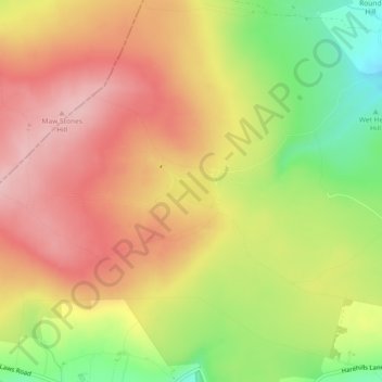
Nombre: Mapa topográfico Keighley Moor Reservoir, altitud, relieve.
Altitud media: 366 m
Altitud mínima: 266 m
Altitud máxima: 439 m
Otros mapas topográficos
Haga clic en un mapa para ver su topografía, su altitud y su relieve.
Ponden Reservoir
United Kingdom > England > Bradford > Keighley > Stanbury
Ponden Reservoir, Keighley, Stanbury, Bradford, West Yorkshire, England, United Kingdom
Altitud media: 313 m
Cackleshaw
United Kingdom > England > Bradford > Keighley > Oakworth > Cackleshaw
Cackleshaw, Keighley, Oakworth, Bradford, West Yorkshire, England, BD22 7JP, United Kingdom
Altitud media: 219 m
High Utley
United Kingdom > England > Bradford > Keighley > High Utley
High Utley, Keighley, Bradford, West Yorkshire, Yorkshire and the Humber, England, BD20 6ES, United Kingdom
Altitud media: 169 m