
Haz una donación
Equípate para tu próxima aventura:
Como asociado de Amazon, este sitio gana comisiones por las compras que califican, sin ningún costo adicional para usted.
Mapa topográfico Pleasantville
Haga clic en el mapa para ver la altitud.
Haz una donación
Equípate para tu próxima aventura:
Como asociado de Amazon, este sitio gana comisiones por las compras que califican, sin ningún costo adicional para usted.
Acerca de este mapa
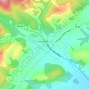
Nombre: Mapa topográfico Pleasantville, altitud, relieve.
Lugar: Pleasantville, Bedford County, Pennsylvania, United States (40.17709 -78.61753 40.18239 -78.60900)
Altitud media: 402 m
Altitud mínima: 350 m
Altitud máxima: 509 m
Haz una donación
Equípate para tu próxima aventura:
Como asociado de Amazon, este sitio gana comisiones por las compras que califican, sin ningún costo adicional para usted.
Otros mapas topográficos
Haga clic en un mapa para ver su topografía, su altitud y su relieve.
New Enterprise
United States > Pennsylvania > Bedford County > South Woodbury Township
Altitud media: 397 m
Blue Knob
United States > Pennsylvania > Bedford County > Pavia Township
Blue Knob (elevation 3,146 feet (959 m)) is a summit in the eastern United States with a broad dome that is the northernmost 3,000-footer in the Allegheny Mountains. It is the highest point in Bedford County, Pennsylvania.
Altitud media: 792 m
Breezewood
United States > Pennsylvania > Bedford County > East Providence Township
Altitud media: 413 m
Haz una donación
Equípate para tu próxima aventura:
Como asociado de Amazon, este sitio gana comisiones por las compras que califican, sin ningún costo adicional para usted.
Texas Corner
United States > Pennsylvania > Bedford County > South Woodbury Township
Altitud media: 462 m
Waterside
United States > Pennsylvania > Bedford County > South Woodbury Township
Altitud media: 431 m
Yellow Creek
United States > Pennsylvania > Bedford County > Hopewell Township > Yellow Creek
Altitud media: 323 m
Haz una donación
Equípate para tu próxima aventura:
Como asociado de Amazon, este sitio gana comisiones por las compras que califican, sin ningún costo adicional para usted.
Chaneysville
United States > Pennsylvania > Bedford County > Southampton Township
Altitud media: 373 m
Haz una donación
Equípate para tu próxima aventura:
Como asociado de Amazon, este sitio gana comisiones por las compras que califican, sin ningún costo adicional para usted.
Blue Knob
United States > Pennsylvania > Bedford County > Pavia Township
Blue Knob (elevation 3,146 feet (959 m)) is a summit in the eastern United States with a broad dome that is the northernmost 3,000-footer in the Allegheny Mountains. It is the highest point in Bedford County, Pennsylvania.
Altitud media: 792 m