
Mapa topográfico Derby
Mapa interactivo
Haga clic en el mapa para ver la altitud.
Acerca de este mapa
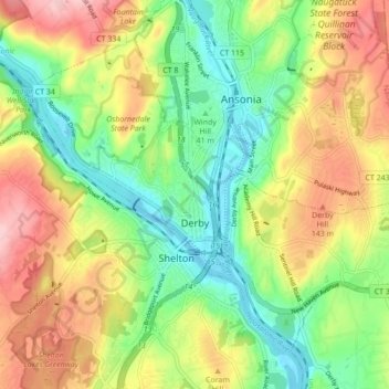
Nombre: Mapa topográfico Derby, altitud, relieve.
Lugar: Derby, New Haven County, Connecticut, 06418, United States (41.30100 -73.12465 41.35291 -73.03914)
Altitud media: 77 m
Altitud mínima: -5 m
Altitud máxima: 180 m
According to the United States Census Bureau, the town has a total area of 5.4 square miles (8.7 km2), of which, 5.0 square miles (13 km2) is land and 0.4 square miles (1.0 km2) (7.41%) is water. The city is home to the 417 acres (0.652 sq mi) Osbornedale State Park. Derby is divided into two main sections by the Naugatuck River: East Derby and Derby Center (Birmingham). The center of Derby is approximately 66 miles (106 km) from New York City. The lowest elevation is 3 ft (1m) and the highest elevation is 466 ft (142m) above sea level.
Otros mapas topográficos
Haga clic en un mapa para ver su topografía, su altitud y su relieve.
Milford
United States > Connecticut > New Haven County
Milford, New Haven County, Connecticut, United States
Altitud media: 17 m
Ansonia
United States > Connecticut > New Haven County
Ansonia, New Haven County, Connecticut, 06401, United States
Altitud media: 76 m
Hamden
United States > Connecticut > New Haven County
Hamden, New Haven County, Connecticut, United States
Altitud media: 64 m
West Haven
United States > Connecticut > New Haven County > West Haven > West Haven
West Haven, New Haven County, Connecticut, 06516, United States
Altitud media: 21 m
Wallingford
United States > Connecticut > New Haven County > Wallingford
Wallingford, New Haven County, Connecticut, 06492, United States
Altitud media: 72 m
New Haven
United States > Connecticut > New Haven County > New Haven
New Haven, New Haven County, Connecticut, United States
Altitud media: 20 m
Long Jetty
United States > Connecticut > New Haven County > Milford
Long Jetty, Milford, New Haven County, Connecticut, 06460, United States
Altitud media: 4 m