
Haz una donación
Equípate para tu próxima aventura:
Como asociado de Amazon, este sitio gana comisiones por las compras que califican, sin ningún costo adicional para usted.
Mapa topográfico Mentone
Haga clic en el mapa para ver la altitud.
Haz una donación
Equípate para tu próxima aventura:
Como asociado de Amazon, este sitio gana comisiones por las compras que califican, sin ningún costo adicional para usted.
Mentone
Mentone is located in eastern DeKalb County at 34°34′20″N 85°34′49″W / 34.57222°N 85.58028°W / 34.57222; -85.58028 (34.572360, -85.580283). It is bordered to the west by the town of Valley Head. The center of town is located on the crest of Lookout Mountain at an elevation of 1,736 feet (529 m). The western border of the town, with Valley Head, follows the western slopes of the mountain. Extending south from the town center is the mountain's ridgecrest that rises to an elevation of 1,785 feet (544 m) within the town limits. The West Fork of the Little River crosses the eastern portion of the town at an elevation less than 100 feet (30 m) below the ridgecrest.
Haz una donación
Equípate para tu próxima aventura:
Como asociado de Amazon, este sitio gana comisiones por las compras que califican, sin ningún costo adicional para usted.
Acerca de este mapa
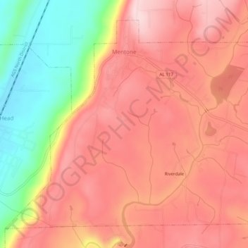
Nombre: Mapa topográfico Mentone, altitud, relieve.
Lugar: Mentone, DeKalb County, Alabama, 35984, United States (34.55130 -85.61363 34.58458 -85.56558)
Altitud media: 471 m
Altitud mínima: 307 m
Altitud máxima: 566 m
Haz una donación
Equípate para tu próxima aventura:
Como asociado de Amazon, este sitio gana comisiones por las compras que califican, sin ningún costo adicional para usted.
Otros mapas topográficos
Haga clic en un mapa para ver su topografía, su altitud y su relieve.
Haz una donación
Equípate para tu próxima aventura:
Como asociado de Amazon, este sitio gana comisiones por las compras que califican, sin ningún costo adicional para usted.