
Mapa topográfico Banská Bystrica
Mapa interactivo
Haga clic en el mapa para ver la altitud.
Acerca de este mapa
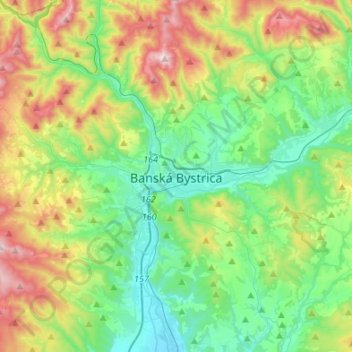
Nombre: Mapa topográfico Banská Bystrica, altitud, relieve.
Altitud media: 566 m
Altitud mínima: 309 m
Altitud máxima: 1.140 m
Banská Bystrica lies at an altitude of 362 metres (1,188 ft) above sea level and covers an area of 103.37 square kilometres (39.9 sq mi). It is about halfway between Slovakia's two largest cities, 208 kilometres (129 mi) north-east from Slovakia's capital Bratislava and 217 kilometres (135 mi) west of Košice. A chain of discrete suburbs and villages connects it with Zvolen, another major town 20 kilometres (12 mi) to the south.
Otros mapas topográficos
Haga clic en un mapa para ver su topografía, su altitud y su relieve.
Hrochoť
Slovakia > Region of Banská Bystrica > District of Banská Bystrica > Hrochoť > Hrochoť
Hrochoť, District of Banská Bystrica, Region of Banská Bystrica, Central Slovakia, 976 37, Slovakia
Altitud media: 626 m
Hrochoť
Slovakia > Region of Banská Bystrica > District of Banská Bystrica
Hrochoť, District of Banská Bystrica, Region of Banská Bystrica, Central Slovakia, 976 37, Slovakia
Altitud media: 597 m
Japeň
Slovakia > Region of Banská Bystrica > District of Banská Bystrica > Dolný Harmanec
Japeň, Dolný Harmanec, District of Banská Bystrica, Region of Banská Bystrica, Central Slovakia, 976 03, Slovakia
Altitud media: 745 m