
Haz una donación
Equípate para tu próxima aventura:
Como asociado de Amazon, este sitio gana comisiones por las compras que califican, sin ningún costo adicional para usted.
Mapa topográfico Ball Ground
Haga clic en el mapa para ver la altitud.
Haz una donación
Equípate para tu próxima aventura:
Como asociado de Amazon, este sitio gana comisiones por las compras que califican, sin ningún costo adicional para usted.
Ball Ground
According to the United States Census Bureau as of 2020, Ball Ground has a total area of 6.3 sq mi (16 km2), of which 0.04 sq mi (0.10 km2), or 0.63%, is water. The city's elevation averages around 1,100 ft (340 m) above sea level, ranging from just over 1,000 ft (300 m) in the valleys to around 1,200 ft (370 m) on several hilltops within the city. Unlike most other parts of Cherokee County, Ball Ground is not in a floodplain and has no typically flood prone areas. To protect the water and surrounding lands, the city government has ordinances in place for stream buffer protection, watershed protection, and wetland protection.
Haz una donación
Equípate para tu próxima aventura:
Como asociado de Amazon, este sitio gana comisiones por las compras que califican, sin ningún costo adicional para usted.
Acerca de este mapa
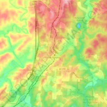
Nombre: Mapa topográfico Ball Ground, altitud, relieve.
Lugar: Ball Ground, Cherokee County, Georgia, United States (34.31118 -84.41254 34.37075 -84.32178)
Altitud media: 331 m
Altitud mínima: 243 m
Altitud máxima: 414 m
Haz una donación
Equípate para tu próxima aventura:
Como asociado de Amazon, este sitio gana comisiones por las compras que califican, sin ningún costo adicional para usted.
Otros mapas topográficos
Haga clic en un mapa para ver su topografía, su altitud y su relieve.
Haz una donación
Equípate para tu próxima aventura:
Como asociado de Amazon, este sitio gana comisiones por las compras que califican, sin ningún costo adicional para usted.
Haz una donación
Equípate para tu próxima aventura:
Como asociado de Amazon, este sitio gana comisiones por las compras que califican, sin ningún costo adicional para usted.