
Haz una donación
Equípate para tu próxima aventura:
Como asociado de Amazon, este sitio gana comisiones por las compras que califican, sin ningún costo adicional para usted.
Mapa topográfico Stiversville
Haga clic en el mapa para ver la altitud.
Haz una donación
Equípate para tu próxima aventura:
Como asociado de Amazon, este sitio gana comisiones por las compras que califican, sin ningún costo adicional para usted.
Acerca de este mapa
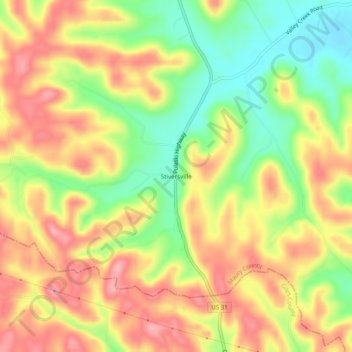
Nombre: Mapa topográfico Stiversville, altitud, relieve.
Altitud media: 286 m
Altitud mínima: 221 m
Altitud máxima: 341 m
Haz una donación
Equípate para tu próxima aventura:
Como asociado de Amazon, este sitio gana comisiones por las compras que califican, sin ningún costo adicional para usted.
Otros mapas topográficos
Haga clic en un mapa para ver su topografía, su altitud y su relieve.
Columbia
United States > Tennessee > Maury County
According to the United States Census Bureau, the city has a total area of 29.6 square miles (77 km2), of which 29.6 square miles (77 km2) is land and 0.03% is water. Incorporated in 1817, the city is at an elevation of 637 feet (194 m).
Altitud media: 214 m
Haz una donación
Equípate para tu próxima aventura:
Como asociado de Amazon, este sitio gana comisiones por las compras que califican, sin ningún costo adicional para usted.