
Mapa topográfico Eichstedt (Altmark)
Mapa interactivo
Haga clic en el mapa para ver la altitud.
Acerca de este mapa
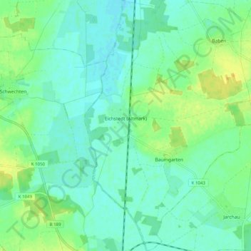
Nombre: Mapa topográfico Eichstedt (Altmark), altitud, relieve.
Altitud media: 34 m
Altitud mínima: 26 m
Altitud máxima: 49 m
Aland | Altmärkische Höhe | Altmärkische Wische | Arneburg | Bismark (Altmark) | Eichstedt (Altmark) | Goldbeck | Hassel | Havelberg | Hohenberg-Krusemark | Iden | Kamern | Klietz | Osterburg (Altmark) | Rochau | Sandau (Elbe) | Schollene | Schönhausen (Elbe) | Seehausen (Altmark) | Stendal | Tangerhütte | Tangermünde | Werben (Elbe) | Wust-Fischbeck | Zehrental