
Haz una donación
Equípate para tu próxima aventura:
Como asociado de Amazon, este sitio gana comisiones por las compras que califican, sin ningún costo adicional para usted.
Mapa topográfico Chiswell Green
Haga clic en el mapa para ver la altitud.
Haz una donación
Equípate para tu próxima aventura:
Como asociado de Amazon, este sitio gana comisiones por las compras que califican, sin ningún costo adicional para usted.
Acerca de este mapa
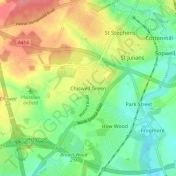
Nombre: Mapa topográfico Chiswell Green, altitud, relieve.
Altitud media: 94 m
Altitud mínima: 63 m
Altitud máxima: 137 m
Haz una donación
Equípate para tu próxima aventura:
Como asociado de Amazon, este sitio gana comisiones por las compras que califican, sin ningún costo adicional para usted.
Otros mapas topográficos
Haga clic en un mapa para ver su topografía, su altitud y su relieve.
St Albans
United Kingdom > England > Hertfordshire > St Albans
St Albans was an ancient borough created following the dissolution of the monastery in 1539. It consisted of the ancient parish of St Albans (also known as the Abbey parish) and parts of St Michael and St Peter. The municipal corporation was reformed by the Municipal Corporations Act 1835 and the boundary was…
Altitud media: 100 m
Highfield Park
United Kingdom > England > Hertfordshire > St Albans > Colney Heath
Altitud media: 87 m
Haz una donación
Equípate para tu próxima aventura:
Como asociado de Amazon, este sitio gana comisiones por las compras que califican, sin ningún costo adicional para usted.
Haz una donación
Equípate para tu próxima aventura:
Como asociado de Amazon, este sitio gana comisiones por las compras que califican, sin ningún costo adicional para usted.
Haz una donación
Equípate para tu próxima aventura:
Como asociado de Amazon, este sitio gana comisiones por las compras que califican, sin ningún costo adicional para usted.