
Mapa topográfico Kyustendil
Mapa interactivo
Haga clic en el mapa para ver la altitud.
Kyustendil
Kyustendil is a national balneological resort at an altitude of 600 metres. There are more than 40 mineral springs in the town. The waters have a high content of sulfite compounds. These are used for the treatment of the locomotory system, gynecological and other kinds of diseases. The resort region includes several baths, balneological complexes and others.
Acerca de este mapa
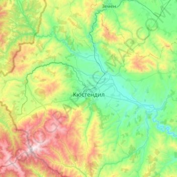
Nombre: Mapa topográfico Kyustendil, altitud, relieve.
Lugar: Kyustendil, Bulgaria (42.09792 22.35980 42.48571 22.89789)
Altitud media: 939 m
Altitud mínima: 402 m
Altitud máxima: 2.246 m
Otros mapas topográficos
Haga clic en un mapa para ver su topografía, su altitud y su relieve.