
Mapa topográfico Wheatley
Mapa interactivo
Haga clic en el mapa para ver la altitud.
Acerca de este mapa
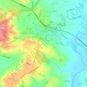
Nombre: Mapa topográfico Wheatley, altitud, relieve.
Altitud media: 90 m
Altitud mínima: 52 m
Altitud máxima: 157 m
Otros mapas topográficos
Haga clic en un mapa para ver su topografía, su altitud y su relieve.
Didcot
United Kingdom > England > Oxfordshire > South Oxfordshire > East Hagbourne
Didcot, East Hagbourne, South Oxfordshire, Oxfordshire, England, United Kingdom
Altitud media: 61 m
Thame
United Kingdom > England > Oxfordshire > South Oxfordshire
Thame, South Oxfordshire, Oxfordshire, England, United Kingdom
Altitud media: 74 m
Stadhampton
United Kingdom > England > Oxfordshire > South Oxfordshire
Stadhampton, South Oxfordshire, Oxfordshire, England, United Kingdom
Altitud media: 61 m