
Haz una donación
Equípate para tu próxima aventura:
Como asociado de Amazon, este sitio gana comisiones por las compras que califican, sin ningún costo adicional para usted.
Mapa topográfico Fruitland
Haga clic en el mapa para ver la altitud.
Haz una donación
Equípate para tu próxima aventura:
Como asociado de Amazon, este sitio gana comisiones por las compras que califican, sin ningún costo adicional para usted.
Acerca de este mapa
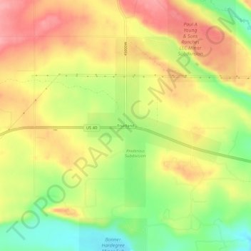
Nombre: Mapa topográfico Fruitland, altitud, relieve.
Lugar: Fruitland, Duchesne County, Utah, 84027, United States (40.19273 -110.85961 40.23273 -110.81961)
Altitud media: 2.028 m
Altitud mínima: 1.971 m
Altitud máxima: 2.075 m
Haz una donación
Equípate para tu próxima aventura:
Como asociado de Amazon, este sitio gana comisiones por las compras que califican, sin ningún costo adicional para usted.
Otros mapas topográficos
Haga clic en un mapa para ver su topografía, su altitud y su relieve.
Roosevelt
United States > Utah > Duchesne County
Roosevelt is situated on U.S. Route 40 in the northeast corner of the state, south of the Uinta Mountains, at an elevation of 5,250 feet (1,600 m). The town was incorporated at a mass meeting of 44 citizens on 21 February 1913. From 1906 to 1914 Roosevelt was in Wasatch County, but in 1914 Duchesne County was…
Altitud media: 1.553 m
Haz una donación
Equípate para tu próxima aventura:
Como asociado de Amazon, este sitio gana comisiones por las compras que califican, sin ningún costo adicional para usted.