
Haz una donación
Equípate para tu próxima aventura:
Como asociado de Amazon, este sitio gana comisiones por las compras que califican, sin ningún costo adicional para usted.
Mapa topográfico Mossville
Haga clic en el mapa para ver la altitud.
Haz una donación
Equípate para tu próxima aventura:
Como asociado de Amazon, este sitio gana comisiones por las compras que califican, sin ningún costo adicional para usted.
Acerca de este mapa
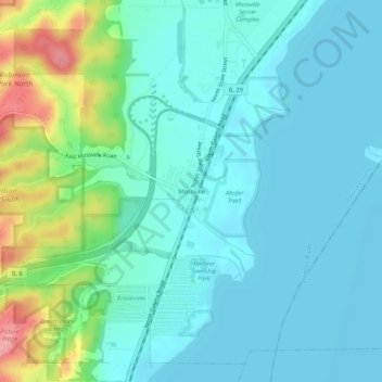
Nombre: Mapa topográfico Mossville, altitud, relieve.
Lugar: Mossville, Peoria County, Illinois, 61552, United States (40.79559 -89.58787 40.83559 -89.54787)
Altitud media: 156 m
Altitud mínima: 133 m
Altitud máxima: 241 m
Haz una donación
Equípate para tu próxima aventura:
Como asociado de Amazon, este sitio gana comisiones por las compras que califican, sin ningún costo adicional para usted.
Otros mapas topográficos
Haga clic en un mapa para ver su topografía, su altitud y su relieve.
Peoria Heights
United States > Illinois > Peoria County
Topographically, the village can be roughly divided into three zones. The Illinois River floodplain, the bluff, and the plateau. While its eastern border is fairly regular with the river's edge, the rest of its municipal border, with Peoria, is quite irregular and convoluted.
Altitud media: 183 m
Haz una donación
Equípate para tu próxima aventura:
Como asociado de Amazon, este sitio gana comisiones por las compras que califican, sin ningún costo adicional para usted.
Haz una donación
Equípate para tu próxima aventura:
Como asociado de Amazon, este sitio gana comisiones por las compras que califican, sin ningún costo adicional para usted.