
Mapa topográfico Rathsweiler
Mapa interactivo
Haga clic en el mapa para ver la altitud.
Rathsweiler
The municipality lies near the river Glan in the Western Palatinate. Rathsweiler lies in the Glan valley near where the Steinalb empties into the Glan at an elevation of 187 m above sea level and at the foot of the Hohlbusch (403 m) and the Nollkopf (402 m). Within the village itself, elevations range from 195 to 220 m above sea level. The municipal area measures 425 ha, of which 116 ha is wooded and roughly 10 ha is settled. In 1987, 160 ha of land was sold to the Federal Republic and it now belongs to the Baumholder troop drilling ground.
Acerca de este mapa
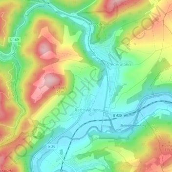
Nombre: Mapa topográfico Rathsweiler, altitud, relieve.
Altitud media: 268 m
Altitud mínima: 183 m
Altitud máxima: 395 m