Mapa topográfico Gottmannsberg
Haga clic en el mapa para ver la altitud.
Acerca de este mapa
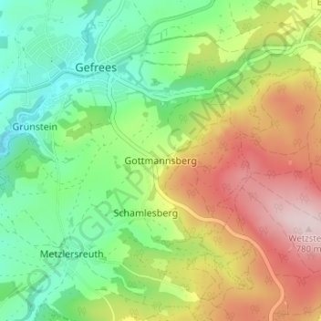
Nombre: Mapa topográfico Gottmannsberg, altitud, relieve.
Altitud media: 606 m
Altitud mínima: 475 m
Altitud máxima: 799 m

Haga clic en el mapa para ver la altitud.
Nombre: Mapa topográfico Gottmannsberg, altitud, relieve.
Altitud media: 606 m
Altitud mínima: 475 m
Altitud máxima: 799 m
Como asociado de Amazon, este sitio gana comisiones por las compras que califican, sin ningún costo adicional para usted.