
Mapa topográfico Vișeu de Sus
Mapa interactivo
Haga clic en el mapa para ver la altitud.
Acerca de este mapa
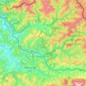
Nombre: Mapa topográfico Vișeu de Sus, altitud, relieve.
Lugar: Vișeu de Sus, Maramureș, Romania (47.65891 24.37557 47.86529 24.88777)
Altitud media: 865 m
Altitud mínima: 348 m
Altitud máxima: 2.266 m
Vișeu de Sus is located in the northeastern part of Maramureș County, on the border with Ukraine. The town lies at the confluence of the rivers Vișeu and Vaser, at an altitude of 427 m (1,401 ft) above sea level, having the characteristics of a mountain city. It neighbors the communes of Moisei to the southeast, Vișeu de Jos to the west, and Poienile de sub Munte to the northwest. It also borders Maramureș Mountains Natural Park to the north, and Rodna Mountains National Park to the south-east. The town administers a surface area of 44,306 ha (109,480 acres), making it the second-largest town by area in Romania.
Otros mapas topográficos
Haga clic en un mapa para ver su topografía, su altitud y su relieve.
Băile Borșa
Băile Borșa, Borșa, Maramureș, 435250, Romania
Altitud media: 917 m
Chiuzbaia
Romania > Maramureș > Baia Sprie > Chiuzbaia
Chiuzbaia, Baia Sprie, Maramureș, 435101, Romania
Altitud media: 635 m
Sighetu Marmatiei
Romania > Maramureș > Sighetu Marmatiei
Sighetu Marmatiei, Sighetu Marmației, Maramureș, 435500, Romania
Altitud media: 312 m