
Haz una donación
Equípate para tu próxima aventura:
Como asociado de Amazon, este sitio gana comisiones por las compras que califican, sin ningún costo adicional para usted.
Mapa topográfico Mount Timpanogos
Haga clic en el mapa para ver la altitud.
Haz una donación
Equípate para tu próxima aventura:
Como asociado de Amazon, este sitio gana comisiones por las compras que califican, sin ningún costo adicional para usted.
Acerca de este mapa
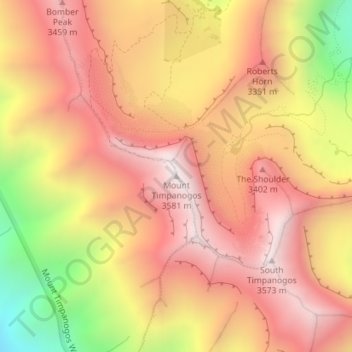
Nombre: Mapa topográfico Mount Timpanogos, altitud, relieve.
Lugar: Mount Timpanogos, Utah County, Utah, 84602, United States (40.39078 -111.64611 40.39088 -111.64601)
Altitud media: 3.139 m
Altitud mínima: 2.412 m
Altitud máxima: 3.573 m
Haz una donación
Equípate para tu próxima aventura:
Como asociado de Amazon, este sitio gana comisiones por las compras que califican, sin ningún costo adicional para usted.
Otros mapas topográficos
Haga clic en un mapa para ver su topografía, su altitud y su relieve.
Eagle Mountain
United States > Utah > Utah County
Eagle Mountain's climate varies drastically between the northeastern Ranches area and the southwestern City Center area. Despite being further south than Salt Lake City, both areas have cooler temperatures due to sitting at a higher elevation. The Ranches section of the city has slightly milder temperatures…
Altitud media: 1.589 m
Orem
United States > Utah > Utah County
Orem is located at 40°17′56″N 111°41′47″W / 40.29889°N 111.69639°W / 40.29889; -111.69639 (40.298753, -111.696486). Situated in a high desert, with an average elevation of 4,756 feet. According to the United States Census Bureau, the city has a total area of 18.4 square miles (48 km2), all…
Altitud media: 1.458 m
Provo
United States > Utah > Utah County
Provo lies in the Utah Valley at an elevation of 4,549 feet (1,387 m). According to the United States Census Bureau, the city has an area of 44.2 square miles (114.4 km2), of which 41.7 square miles (107.9 km2) is land and 2.5 square miles (6.5 km2), or 5.66%, is water.
Altitud media: 1.728 m
Haz una donación
Equípate para tu próxima aventura:
Como asociado de Amazon, este sitio gana comisiones por las compras que califican, sin ningún costo adicional para usted.
American Fork
United States > Utah > Utah County
The elevation is 4,566 feet (1,392 m) above sea level.
Altitud media: 1.405 m
Haz una donación
Equípate para tu próxima aventura:
Como asociado de Amazon, este sitio gana comisiones por las compras que califican, sin ningún costo adicional para usted.
Mapleton
United States > Utah > Utah County
According to the United States Census Bureau, the city has a total area of 12.6 square miles (32.6 km2), all land. The community lies at an elevation of 4,700 feet (1,400 m) above sea level.
Altitud media: 1.682 m
Saratoga Springs
United States > Utah > Utah County
Saratoga Springs is a city in Utah County, Utah, United States. The elevation is 4,505 feet. It is part of the Provo–Orem, Utah Metropolitan Statistical Area. The city is a relatively new development along the northwestern shores of Utah Lake. It was incorporated on December 31, 1997 and has been growing…
Altitud media: 1.495 m
Haz una donación
Equípate para tu próxima aventura:
Como asociado de Amazon, este sitio gana comisiones por las compras que califican, sin ningún costo adicional para usted.
Haz una donación
Equípate para tu próxima aventura:
Como asociado de Amazon, este sitio gana comisiones por las compras que califican, sin ningún costo adicional para usted.
Eagle Mountain
United States > Utah > Utah County
Eagle Mountain's climate varies drastically between the northeastern Ranches area and the southwestern City Center area. Despite being further south than Salt Lake City, both areas have cooler temperatures due to sitting at a higher elevation. The Ranches section of the city has slightly milder temperatures…
Altitud media: 1.589 m
Provo
United States > Utah > Utah County
Provo lies on the eastern bank of Utah Lake in Utah Valley at an elevation of 4,549 feet (1,387 m). According to the United States Census Bureau, the city has an area of 44.2 square miles (114.4 km2), of which 41.7 square miles (107.9 km2) is land and 2.5 square miles (6.5 km2), or 5.66%, is water.
Altitud media: 1.728 m
Haz una donación
Equípate para tu próxima aventura:
Como asociado de Amazon, este sitio gana comisiones por las compras que califican, sin ningún costo adicional para usted.
Saratoga Springs
United States > Utah > Utah County
Saratoga Springs is a city in Utah County, Utah, United States. The elevation is 4,505 feet. It is part of the Provo–Orem, Utah Metropolitan Statistical Area. The city is a relatively new development along the northwestern shores of Utah Lake. It was incorporated on December 31, 1997 and has been growing…
Altitud media: 1.500 m
American Fork
United States > Utah > Utah County
Elevations throughout the city range from 4,566 feet (1,392 m) to 4,619 feet (1,408 m) above sea level.
Altitud media: 1.405 m
Haz una donación
Equípate para tu próxima aventura:
Como asociado de Amazon, este sitio gana comisiones por las compras que califican, sin ningún costo adicional para usted.
Provo
United States > Utah > Utah County
Provo lies on the eastern bank of Utah Lake in Utah Valley at an elevation of 4,549 feet (1,387 m). According to the United States Census Bureau, the city has an area of 44.2 square miles (114.4 km2), of which 41.7 square miles (107.9 km2) is land and 2.5 square miles (6.5 km2), or 5.66%, is water.
Altitud media: 1.728 m
Mapleton
United States > Utah > Utah County
According to the United States Census Bureau, the city has a total area of 12.6 square miles (32.6 km2), all land. The community lies at an elevation of 4,700 feet (1,400 m) above sea level.
Altitud media: 1.682 m
Haz una donación
Equípate para tu próxima aventura:
Como asociado de Amazon, este sitio gana comisiones por las compras que califican, sin ningún costo adicional para usted.
Provo
United States > Utah > Utah County
Provo lies on the eastern bank of Utah Lake in Utah Valley at an elevation of 4,549 feet (1,387 m). According to the United States Census Bureau, the city has an area of 44.2 square miles (114.4 km2), of which 41.7 square miles (107.9 km2) is land and 2.5 square miles (6.5 km2), or 5.66%, is water.
Altitud media: 1.728 m