
Mapa topográfico Conservation Area
Haga clic en el mapa para ver la altitud.
Acerca de este mapa
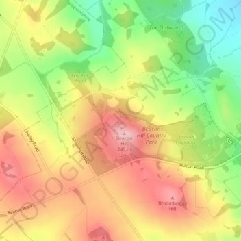
Nombre: Mapa topográfico Conservation Area, altitud, relieve.
Altitud media: 168 m
Altitud mínima: 75 m
Altitud máxima: 247 m
Otros mapas topográficos
Haga clic en un mapa para ver su topografía, su altitud y su relieve.
South Croxton
United Kingdom > England > Leicestershire > Charnwood > South Croxton
The highest point is the church, at 120 m above mean sea level. The lowest altitude is 85 m by the Queniborough Brook.
Altitud media: 108 m
Beeby
United Kingdom > England > Leicestershire > Charnwood
The physical and historical development of the hamlet has been strongly influenced by the local topography and its relative isolation. Beeby is situated within an established agricultural landscape largely in pastoral use. Until 1904 the east-west route was the only route through the hamlet, which was referred…
Altitud media: 101 m
Barrow upon Soar
United Kingdom > England > Leicestershire > Charnwood > Barrow upon Soar
Altitud media: 62 m
Charnwood Water
United Kingdom > England > Leicestershire > Charnwood > Woodthorpe
Altitud media: 47 m
Six Hills
United Kingdom > England > Leicestershire > Charnwood > Burton on the Wolds
Altitud media: 128 m
Barrow upon Soar
United Kingdom > England > Leicestershire > Charnwood > Barrow upon Soar
Altitud media: 62 m