
Mapa topográfico Geyershof
Mapa interactivo
Haga clic en el mapa para ver la altitud.
Acerca de este mapa
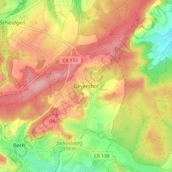
Nombre: Mapa topográfico Geyershof, altitud, relieve.
Lugar: Geyershof, Bech, Kanton Echternach, 6251, Luxemburg (49.74579 6.36680 49.78579 6.40680)
Altitud media: 342 m
Altitud mínima: 261 m
Altitud máxima: 406 m
Otros mapas topográficos
Haga clic en un mapa para ver su topografía, su altitud y su relieve.
Müllerthal
Luxemburg > Kanton Echternach > Waldbillig
Müllerthal, Waldbillig, Kanton Echternach, 6245, Luxemburg
Altitud media: 313 m