
Mapa topográfico Hollis
Mapa interactivo
Haga clic en el mapa para ver la altitud.
Acerca de este mapa
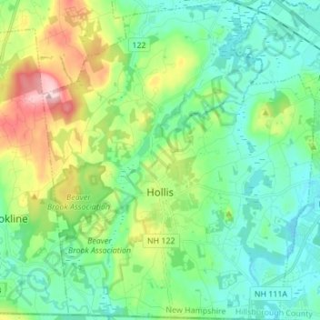
Nombre: Mapa topográfico Hollis, altitud, relieve.
Lugar: Hollis, Hillsborough County, New Hampshire, United States (42.70280 -71.64186 42.80359 -71.52490)
Altitud media: 101 m
Altitud mínima: 46 m
Altitud máxima: 246 m
Otros mapas topográficos
Haga clic en un mapa para ver su topografía, su altitud y su relieve.
Thorntons Ferry
United States > New Hampshire > Hillsborough County > Merrimack
Thorntons Ferry, Merrimack, Hillsborough County, New Hampshire, 03054, United States
Altitud media: 54 m
Manchester
United States > New Hampshire > Hillsborough County
Manchester, Hillsborough County, New Hampshire, United States
Altitud media: 96 m
Amherst
United States > New Hampshire > Hillsborough County > Amherst
Amherst, Hillsborough County, New Hampshire, 03031, United States
Altitud media: 127 m
Nashua
United States > New Hampshire > Hillsborough County > Nashua
Nashua, Hillsborough County, New Hampshire, 03060-03064, United States
Altitud media: 82 m
Nashua
United States > New Hampshire > Hillsborough County
Nashua, Hillsborough County, New Hampshire, United States
Altitud media: 62 m