
Haz una donación
Equípate para tu próxima aventura:
Como asociado de Amazon, este sitio gana comisiones por las compras que califican, sin ningún costo adicional para usted.
Mapa topográfico Snellville
Haga clic en el mapa para ver la altitud.
Haz una donación
Equípate para tu próxima aventura:
Como asociado de Amazon, este sitio gana comisiones por las compras que califican, sin ningún costo adicional para usted.
Snellville
Compared to most large cities around the world at approximately the same latitude (33°39'), such as Beirut, Casablanca, Dallas, Los Angeles, and Phoenix, Snellville has lower average winter temperatures. The primary reason for this is that the North American continent extends into high latitudes that allows systems to form and move eastward and southward without obstruction by major mountain ranges. Other factors include Snellville's distance from large bodies of water; its higher elevation, which can lead to rapid weather changes; prevailing wind patterns; and extensive tree cover, which reduces the urban heat island effect (an advantage during summer).
Haz una donación
Equípate para tu próxima aventura:
Como asociado de Amazon, este sitio gana comisiones por las compras que califican, sin ningún costo adicional para usted.
Acerca de este mapa
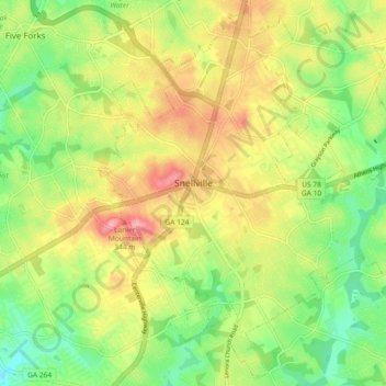
Nombre: Mapa topográfico Snellville, altitud, relieve.
Lugar: Snellville, Gwinnett County, Georgia, United States (33.81839 -84.04291 33.89217 -83.95093)
Altitud media: 300 m
Altitud mínima: 247 m
Altitud máxima: 363 m
Haz una donación
Equípate para tu próxima aventura:
Como asociado de Amazon, este sitio gana comisiones por las compras que califican, sin ningún costo adicional para usted.
Otros mapas topográficos
Haga clic en un mapa para ver su topografía, su altitud y su relieve.
Yellow River Post Office Site
United States > Georgia > Gwinnett County > Lilburn
Altitud media: 275 m
Haz una donación
Equípate para tu próxima aventura:
Como asociado de Amazon, este sitio gana comisiones por las compras que califican, sin ningún costo adicional para usted.
Pine Ridge Country Club Estates
United States > Georgia > Gwinnett County > Lawrenceville
Altitud media: 323 m
Haz una donación
Equípate para tu próxima aventura:
Como asociado de Amazon, este sitio gana comisiones por las compras que califican, sin ningún costo adicional para usted.