
Mapa topográfico Saint John River
Mapa interactivo
Haga clic en el mapa para ver la altitud.
Acerca de este mapa
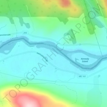
Nombre: Mapa topográfico Saint John River, altitud, relieve.
Altitud media: 208 m
Altitud mínima: 147 m
Altitud máxima: 409 m
When the Europeans arrived into Wolastokuk, the homeland of the Maliseet Nation and Saint John River basin, they found the locals hunting, gathering, and farming near the banks of the river. European colonists may have used fields and town sites prepared by the natives. Archaeological evidence is that the Maliseet had economic and cultural ties with large portions of North America from their country's homebase within the Wabanaki Confederacy of Dawnland. The Maliseet dealt with freshets by having their village above the floodplain, for example Meductic, while cultivating at a lower elevation where the fields were fertilized by the floodwaters. The Maliseet were highly mobile and the Saint John River was a primary means of transportation.
Otros mapas topográficos
Haga clic en un mapa para ver su topografía, su altitud y su relieve.
Fort Kent Mills
United States > Maine > Aroostook County > Fort Kent
Fort Kent Mills, Fort Kent, Aroostook County, Maine, 04743, United States
Altitud media: 213 m
Fort Kent
United States > Maine > Aroostook County > Fort Kent
Fort Kent, Aroostook County, Maine, United States
Altitud media: 217 m