
Mapa topográfico Omsk
Mapa interactivo
Haga clic en el mapa para ver la altitud.
Acerca de este mapa
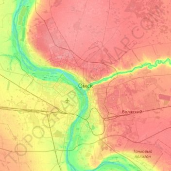
Nombre: Mapa topográfico Omsk, altitud, relieve.
Lugar: Omsk, Omsk Oblast, Siberian Federal District, 644000, Russia (54.83138 73.21153 55.15138 73.53153)
Altitud media: 105 m
Altitud mínima: 62 m
Altitud máxima: 137 m
Omsk is situated in the south of the West Siberian Plain along the banks of the north-flowing Irtysh at its confluence with the Om River. The city has an elevation of 87 meters (285 ft) above mean sea level at its highest point.