
Haz una donación
Equípate para tu próxima aventura:
Como asociado de Amazon, este sitio gana comisiones por las compras que califican, sin ningún costo adicional para usted.
Mapa topográfico Douglas
Haga clic en el mapa para ver la altitud.
Haz una donación
Equípate para tu próxima aventura:
Como asociado de Amazon, este sitio gana comisiones por las compras que califican, sin ningún costo adicional para usted.
Douglas
Douglas has a record of its elevation above sea level of 1030.22 meters (3379.99 feet). Comparing Douglas district's yearly temperature to South Africa's averages, the records show that it is 4.01% higher with a temperature 25.23 °C (77.41 °F). Douglas is known for its Subtropical desert climate with 38.78 rainy days (10.62% of the time) and precipitation of about 19.31 millimeters (0.76 inches) annually.
Haz una donación
Equípate para tu próxima aventura:
Como asociado de Amazon, este sitio gana comisiones por las compras que califican, sin ningún costo adicional para usted.
Acerca de este mapa
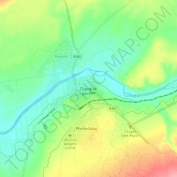
Nombre: Mapa topográfico Douglas, altitud, relieve.
Altitud media: 1.010 m
Altitud mínima: 975 m
Altitud máxima: 1.072 m
Haz una donación
Equípate para tu próxima aventura:
Como asociado de Amazon, este sitio gana comisiones por las compras que califican, sin ningún costo adicional para usted.
Otros mapas topográficos
Haga clic en un mapa para ver su topografía, su altitud y su relieve.
Mokala National Park
South Africa > Northern Cape > Pixley ka Seme District Municipality > Siyancuma Local Municipality
The Northern Cape is a dry region with fluctuating temperatures and differing topographies. The weather is typically that of desert and semi-desert areas. The annual rainfall is never high (between 300–500 mm, average 400 mm) and is always lower than the rate of evaporation. Summers (from December to…
Altitud media: 1.169 m
Boegoeberg Dam
South Africa > Northern Cape > Pixley ka Seme District Municipality > Siyancuma Local Municipality
Altitud media: 935 m