
Haz una donación
Equípate para tu próxima aventura:
Como asociado de Amazon, este sitio gana comisiones por las compras que califican, sin ningún costo adicional para usted.
Mapa topográfico Fancheng District
Haga clic en el mapa para ver la altitud.
Haz una donación
Equípate para tu próxima aventura:
Como asociado de Amazon, este sitio gana comisiones por las compras que califican, sin ningún costo adicional para usted.
Acerca de este mapa
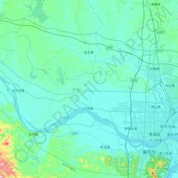
Nombre: Mapa topográfico Fancheng District, altitud, relieve.
Lugar: Fancheng District, Xiangyang, Hubei, 441000, China (32.02059 111.74500 32.25462 112.17011)
Altitud media: 91 m
Altitud mínima: 52 m
Altitud máxima: 421 m
Haz una donación
Equípate para tu próxima aventura:
Como asociado de Amazon, este sitio gana comisiones por las compras que califican, sin ningún costo adicional para usted.
Otros mapas topográficos
Haga clic en un mapa para ver su topografía, su altitud y su relieve.
Mount Wudang
China > Hubei > Danjiangkou City
Modern maps show the elevation of the highest of the peaks in the Wudang Shan "proper" as 1612 meters; however, the entire Wudangshan range has somewhat higher elevations elsewhere.
Altitud media: 1.172 m
Haz una donación
Equípate para tu próxima aventura:
Como asociado de Amazon, este sitio gana comisiones por las compras que califican, sin ningún costo adicional para usted.
Haz una donación
Equípate para tu próxima aventura:
Como asociado de Amazon, este sitio gana comisiones por las compras que califican, sin ningún costo adicional para usted.
Yuxi
Tempered by the low latitude and moderate elevation, Yuxi has a mild subtropical highland climate (Köppen Cwb), with short, mild, dry winters, and warm, rainy summers. Frost may occur in winter but the days still generally warm up to around 17 °C (63 °F). During summer, a majority of the days features some…
Altitud media: 66 m
Haz una donación
Equípate para tu próxima aventura:
Como asociado de Amazon, este sitio gana comisiones por las compras que califican, sin ningún costo adicional para usted.
Haz una donación
Equípate para tu próxima aventura:
Como asociado de Amazon, este sitio gana comisiones por las compras que califican, sin ningún costo adicional para usted.