
Mapa topográfico Daocheng County
Mapa interactivo
Haga clic en el mapa para ver la altitud.
Acerca de este mapa
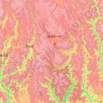
Nombre: Mapa topográfico Daocheng County, altitud, relieve.
Lugar: Daocheng County, Kardze, Sichuan, 627700, China (27.96542 99.84888 29.70734 100.61317)
Altitud media: 3.926 m
Altitud mínima: 1.962 m
Altitud máxima: 5.922 m
Daocheng County or Dapba in Tibetan (Tibetan: འདབ་པ་རྫོང་།; Chinese: 稻城县) is a county of western Sichuan Province, China, located in the eastern Hengduan Mountains. It is under the administration of the Garzê Tibetan Autonomous Prefecture with an overwhelmingly Tibetan population. Its latitude ranges from 27° 58' to 29° 30' N and longitude 99° 56' to 100° 36', and reaches 174 kilometres (108 mi) in north–south extent and 63 km (39 mi) in east–west width, with elevations ranging from 2,000 to 6,032 m (6,562 to 19,790 ft).
Otros mapas topográficos
Haga clic en un mapa para ver su topografía, su altitud y su relieve.
Jiuzhaigou
China > Sichuan > Jiuzhaigou County
Jiuzhaigou, Jiuzhaigou County, Ngawa Tibetan and Qiang Autonomous Prefecture, Sichuan, 623400, China
Altitud media: 2.520 m
Ngawa Tibetan and Qiang Autonomous Prefecture
Ngawa Tibetan and Qiang Autonomous Prefecture, Sichuan, China
Altitud media: 3.542 m
Ngawa
China > Sichuan > Ngawa County
Ngawa, Ngawa County, Ngawa Tibetan and Qiang Autonomous Prefecture, Sichuan, 624600, China
Altitud media: 3.744 m
巴拉格宗雪山
China > Sichuan > Dêrong County
巴拉格宗雪山, Dêrong County, Kardze, Sichuan, China
Altitud media: 4.772 m
Mount Emei
Mount Emei, Emeishan City, Leshan City, Sichuan, China
Altitud media: 2.443 m