
Haz una donación
Equípate para tu próxima aventura:
Como asociado de Amazon, este sitio gana comisiones por las compras que califican, sin ningún costo adicional para usted.
Mapa topográfico Vaughns Corners
Haga clic en el mapa para ver la altitud.
Haz una donación
Equípate para tu próxima aventura:
Como asociado de Amazon, este sitio gana comisiones por las compras que califican, sin ningún costo adicional para usted.
Acerca de este mapa
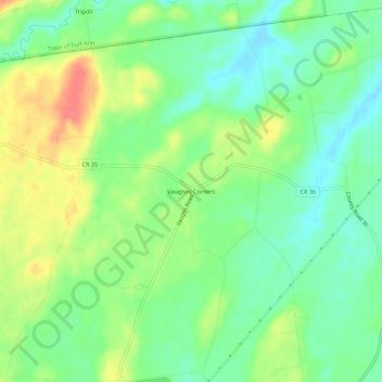
Nombre: Mapa topográfico Vaughns Corners, altitud, relieve.
Altitud media: 91 m
Altitud mínima: 67 m
Altitud máxima: 128 m
Haz una donación
Equípate para tu próxima aventura:
Como asociado de Amazon, este sitio gana comisiones por las compras que califican, sin ningún costo adicional para usted.
Otros mapas topográficos
Haga clic en un mapa para ver su topografía, su altitud y su relieve.
Haz una donación
Equípate para tu próxima aventura:
Como asociado de Amazon, este sitio gana comisiones por las compras que califican, sin ningún costo adicional para usted.
Fort Edward Feeder Canal
United States > New York > Washington County > Village of Fort Edward
Altitud media: 57 m
Haz una donación
Equípate para tu próxima aventura:
Como asociado de Amazon, este sitio gana comisiones por las compras que califican, sin ningún costo adicional para usted.
Batten Kill
United States > New York > Washington County
Mad Tom Brook rises on the southern slope of Mount Tabor in the northwestern part of the town of Peru at an altitude of 2,900 feet (880 m) above sea level. It flows southward and south-westward to East Dorset where it joins the beginning of the Batten Kill from the north. Its length is about 5.5 miles (8.9…
Altitud media: 337 m
Haz una donación
Equípate para tu próxima aventura:
Como asociado de Amazon, este sitio gana comisiones por las compras que califican, sin ningún costo adicional para usted.