
Mapa topográfico Fitzwilliam
Mapa interactivo
Haga clic en el mapa para ver la altitud.
Acerca de este mapa
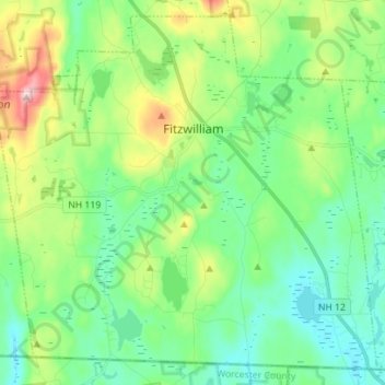
Nombre: Mapa topográfico Fitzwilliam, altitud, relieve.
Altitud media: 345 m
Altitud mínima: 261 m
Altitud máxima: 565 m
According to the United States Census Bureau, the town has a total area of 36.0 square miles (93.3 km2), of which 34.6 square miles (89.7 km2) are land and 1.4 square miles (3.6 km2) are water, comprising 3.88% of the town. Little Monadnock Mountain, elevation 1,883 feet (574 m), is the highest point in Fitzwilliam, located in the western part of town. The Metacomet-Monadnock Trail traverses the summit, as does a shorter side trail from Rhododendron State Park. The town is drained by the South Branch of the Ashuelot River, the source of which is Bowker Pond. Fitzwilliam lies fully within the Connecticut River watershed.
Otros mapas topográficos
Haga clic en un mapa para ver su topografía, su altitud y su relieve.
Stoddard
United States > New Hampshire > Cheshire County
Stoddard, Cheshire County, New Hampshire, United States
Altitud media: 451 m
Chesterfield
United States > New Hampshire > Cheshire County
Chesterfield, Cheshire County, New Hampshire, United States
Altitud media: 229 m
Harrisville
United States > New Hampshire > Cheshire County
Harrisville, Cheshire County, New Hampshire, 03450, United States
Altitud media: 422 m
Gilboa Mountain
United States > New Hampshire > Cheshire County > Westmoreland
Gilboa Mountain, Westmoreland, Cheshire County, New Hampshire, 03467, United States
Altitud media: 331 m
Westmoreland
United States > New Hampshire > Cheshire County
Westmoreland, Cheshire County, New Hampshire, 03467, United States
Altitud media: 228 m
Alstead
United States > New Hampshire > Cheshire County
Alstead, Cheshire County, New Hampshire, United States
Altitud media: 289 m
West Chesterfield
United States > New Hampshire > Cheshire County > Chesterfield
West Chesterfield, Chesterfield, Cheshire County, New Hampshire, 03466, United States
Altitud media: 168 m
Rindge
United States > New Hampshire > Cheshire County
Rindge, Cheshire County, New Hampshire, United States
Altitud media: 343 m
Marlborough
United States > New Hampshire > Cheshire County
Marlborough, Cheshire County, New Hampshire, 03455, United States
Altitud media: 299 m
Winchester
United States > New Hampshire > Cheshire County > Winchester
Winchester, Cheshire County, New Hampshire, United States
Altitud media: 167 m
Pisgah State Park
United States > New Hampshire > Cheshire County > Winchester
Pisgah State Park, Winchester, Cheshire County, New Hampshire, United States
Altitud media: 250 m
Keene
United States > New Hampshire > Cheshire County
Keene, Cheshire County, New Hampshire, United States
Altitud media: 263 m
Harper Acres
United States > New Hampshire > Cheshire County > Keene
Harper Acres, Keene, Cheshire County, New Hampshire, 03431, United States
Altitud media: 156 m
Jaffrey
United States > New Hampshire > Cheshire County
Jaffrey, Cheshire County, New Hampshire, 03452, United States
Altitud media: 351 m
Monte Rosa
United States > New Hampshire > Cheshire County > Jaffrey
Monte Rosa, Jaffrey, Cheshire County, New Hampshire, United States
Altitud media: 634 m