
Mapa topográfico Poteau
Mapa interactivo
Haga clic en el mapa para ver la altitud.
Acerca de este mapa
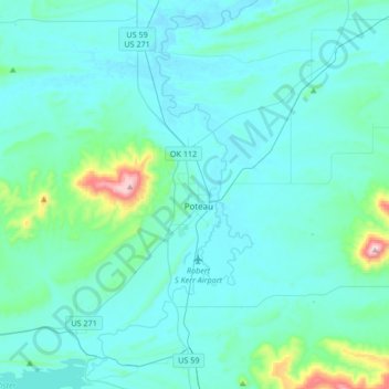
Nombre: Mapa topográfico Poteau, altitud, relieve.
Lugar: Poteau, Le Flore County, Oklahoma, 74953, United States (34.92772 -94.73447 35.20218 -94.57137)
Altitud media: 189 m
Altitud mínima: 125 m
Altitud máxima: 770 m
The city is located in the valley below Cavanal Hill, dubbed the "World's Highest Hill" with a signed elevation of 1,999 feet (609 m). The location was a subject of extensive coal mining in the first half of the 20th Century, and a railway, eventually called the Poteau and Cavanal Mountain Railroad, served the mines. The summit elevation of the hill is 2,385 feet (727 m) above sea level, while the hill rises 1,960 feet (600 m) above the Poteau River on the east side of Poteau. The Poteau River is the only river in Oklahoma that flows north. It flows into Arkansas where it meets the Arkansas River at Belle Point in Fort Smith.
Otros mapas topográficos
Haga clic en un mapa para ver su topografía, su altitud y su relieve.
Heavener
United States > Oklahoma > Le Flore County
Heavener, Le Flore County, Oklahoma, 74937, United States
Altitud media: 193 m
Talimena State Park
United States > Oklahoma > Le Flore County
Talimena State Park, Le Flore County, Oklahoma, United States
Altitud media: 345 m