
Mapa topográfico Fort McMurray
Mapa interactivo
Haga clic en el mapa para ver la altitud.
Fort McMurray
The community lies at a lower elevation than most other parts of Alberta, so under the right conditions it can be a "hot spot" for Alberta, or even all of Canada (as in April 1980 when its daily mean temperature of 10 °C (50 °F) was unsurpassed by any other Canadian station).
Acerca de este mapa
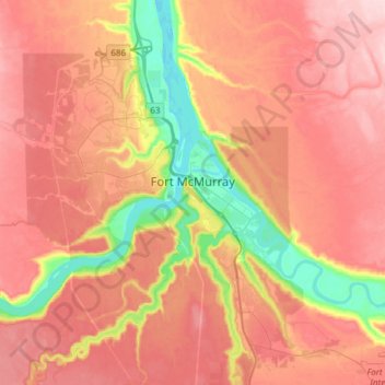
Nombre: Mapa topográfico Fort McMurray, altitud, relieve.
Lugar: Fort McMurray, Wood Buffalo, Alberta, Canada (56.64375 -111.51094 56.80447 -111.20705)
Altitud media: 345 m
Altitud mínima: 234 m
Altitud máxima: 422 m