
Mapa topográfico Mount Price
Mapa interactivo
Haga clic en el mapa para ver la altitud.
Mount Price
Mount Price is a small stratovolcano in the Garibaldi Ranges of the Pacific Ranges in southwestern British Columbia, Canada. It is located 10 km (6.2 mi) southeast of the abandoned settlement of Garibaldi above the eastern flank of the Cheakamus River valley. With a summit elevation of 2,049 m (6,722 ft), it rises above the surrounding landscape on the western shore of Garibaldi Lake. The mountain contains a number of subfeatures, including Clinker Peak on its western flank, which was the source of two thick lava flows between 15,000 and 8,000 years ago that ponded against glacial ice. These lava flows are structurally unstable, having produced large landslides as recently as the 1850s. A large provincial park surrounds Mount Price and other volcanoes in its vicinity.
Acerca de este mapa
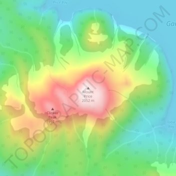
Nombre: Mapa topográfico Mount Price, altitud, relieve.
Altitud media: 1.672 m
Altitud mínima: 1.461 m
Altitud máxima: 2.039 m
Otros mapas topográficos
Haga clic en un mapa para ver su topografía, su altitud y su relieve.
Garibaldi Lake
Canada > British Columbia > Squamish-Lillooet Regional District > Area D (Elaho/Garibaldi)
All recreational activities in the area are governed by the regulations of Garibaldi Provincial Park. Primary access to the lake is via the 9 km (5.6 mi) long Garibaldi Lake Trail, which gains approximately 920 m (3,020 ft) of elevation from the Rubble Creek Trailhead. There are campgrounds and day-use…
Altitud media: 1.620 m
Daisy Lake
Canada > British Columbia > Squamish-Lillooet Regional District > Area D (Elaho/Garibaldi)
Altitud media: 621 m