
Mapa topográfico Yellowstone River
Mapa interactivo
Haga clic en el mapa para ver la altitud.
Acerca de este mapa
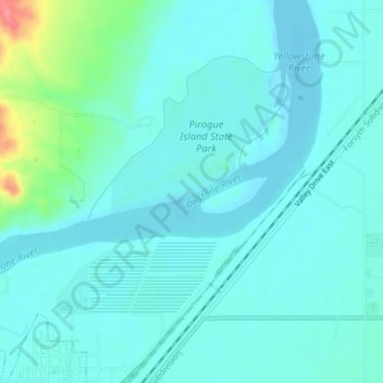
Nombre: Mapa topográfico Yellowstone River, altitud, relieve.
Altitud media: 720 m
Altitud mínima: 707 m
Altitud máxima: 786 m
The mainstem of the Yellowstone River is more than 700 miles (1,100 km) long. At the headwaters, elevations exceed 12,800 feet (3,900 m) above sea level and descends to 1,850 feet (560 m) at the confluence with the Missouri River in far western North Dakota. The watershed spans 34,167 square miles (88,490 km2). The area contains many lakes, including Yellowstone Lake. There are no storage dams located on the mainstem of the Yellowstone River. However, the watershed contains five major reservoirs built on tributary rivers: Bull Lake, Boysen, Buffalo Bill, Big Horn, Tongue River, and Lake De Smet reservoirs.
Otros mapas topográficos
Haga clic en un mapa para ver su topografía, su altitud y su relieve.
Westwood Estates
United States > Montana > Custer County > Miles City
Westwood Estates, Miles City, Custer County, Montana, 59301, United States
Altitud media: 724 m
Carbon Hill Trailer Court
United States > Montana > Custer County > Miles City
Carbon Hill Trailer Court, Miles City, Custer County, Montana, 59301, United States
Altitud media: 732 m
Miles City
United States > Montana > Custer County
Miles City, Custer County, Montana, United States
Altitud media: 724 m
Cook Lake
United States > Montana > Custer County > Miles City > Smiths Trailer Court
Cook Lake, Smiths Trailer Court, Miles City, Custer County, Montana, United States
Altitud media: 721 m