
Haz una donación
Equípate para tu próxima aventura:
Como asociado de Amazon, este sitio gana comisiones por las compras que califican, sin ningún costo adicional para usted.
Mapa topográfico Cairo
Haga clic en el mapa para ver la altitud.
Haz una donación
Equípate para tu próxima aventura:
Como asociado de Amazon, este sitio gana comisiones por las compras que califican, sin ningún costo adicional para usted.
Cairo
Cairo (/ˈkɛəroʊ/ KAIR-oh, sometimes /ˈkeɪroʊ/ KAY-roh) is the southernmost city in Illinois and the county seat of Alexander County. A river city, Cairo has the lowest elevation of any location in Illinois and is the only Illinois city to be surrounded by levees. It is in the river-crossed area of Southern Illinois known as "Little Egypt", for which the city is named, after Egypt's capital on the Nile. The city is coterminous with Cairo Precinct.
Haz una donación
Equípate para tu próxima aventura:
Como asociado de Amazon, este sitio gana comisiones por las compras que califican, sin ningún costo adicional para usted.
Acerca de este mapa
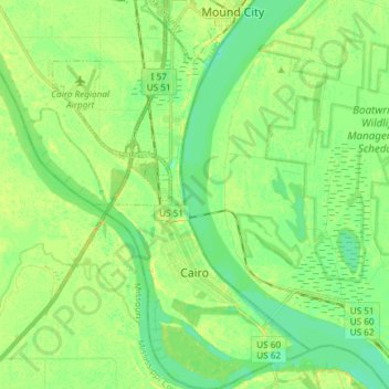
Nombre: Mapa topográfico Cairo, altitud, relieve.
Lugar: Cairo, Alexander County, Illinois, 62914, United States (36.97030 -89.23146 37.08887 -89.13292)
Altitud media: 95 m
Altitud mínima: 85 m
Altitud máxima: 107 m
Haz una donación
Equípate para tu próxima aventura:
Como asociado de Amazon, este sitio gana comisiones por las compras que califican, sin ningún costo adicional para usted.
Otros mapas topográficos
Haga clic en un mapa para ver su topografía, su altitud y su relieve.
Haz una donación
Equípate para tu próxima aventura:
Como asociado de Amazon, este sitio gana comisiones por las compras que califican, sin ningún costo adicional para usted.