
Mapa topográfico Käerjeng
Mapa interactivo
Haga clic en el mapa para ver la altitud.
Acerca de este mapa
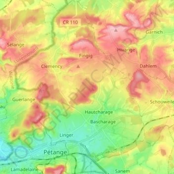
Nombre: Mapa topográfico Käerjeng, altitud, relieve.
Lugar: Käerjeng, Kanton Kapellen, Luxemburg (49.54619 5.84777 49.62922 5.95796)
Altitud media: 331 m
Altitud mínima: 262 m
Altitud máxima: 403 m
Otros mapas topográficos
Haga clic en un mapa para ver su topografía, su altitud y su relieve.
Bridel
Bridel, Kopstal, Kanton Kapellen, 8133, Luxemburg
Altitud media: 338 m
Capellen
Luxemburg > Kanton Kapellen > Mamer
Capellen, Mamer, Kanton Kapellen, Luxemburg
Altitud media: 317 m