
Haz una donación
Equípate para tu próxima aventura:
Como asociado de Amazon, este sitio gana comisiones por las compras que califican, sin ningún costo adicional para usted.
Mapa topográfico Melville
Haga clic en el mapa para ver la altitud.
Haz una donación
Equípate para tu próxima aventura:
Como asociado de Amazon, este sitio gana comisiones por las compras que califican, sin ningún costo adicional para usted.
Melville
Long Island's highest point is Jayne's Hill in the neighboring hamlet of West Hills, with an elevation of 387 feet (118 m) to 400.9 feet (122.2 m) above sea level.
Haz una donación
Equípate para tu próxima aventura:
Como asociado de Amazon, este sitio gana comisiones por las compras que califican, sin ningún costo adicional para usted.
Acerca de este mapa
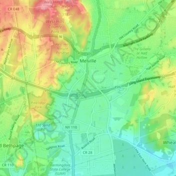
Nombre: Mapa topográfico Melville, altitud, relieve.
Altitud media: 53 m
Altitud mínima: 18 m
Altitud máxima: 113 m
Haz una donación
Equípate para tu próxima aventura:
Como asociado de Amazon, este sitio gana comisiones por las compras que califican, sin ningún costo adicional para usted.
Otros mapas topográficos
Haga clic en un mapa para ver su topografía, su altitud y su relieve.
Jayne's Hill
United States > New York > Suffolk County > Town of Huntington
Jayne's Hill (also known as High Hill, West Hills, Oakley's Hill, and Janes Hill) is the highest point on Long Island, New York, with an elevation of between 387 feet (118 m) and 400.9 feet (122.2 m) above sea level. It is situated on the Harbor Hill moraine, a terminal moraine that makes up the northern spine…
Altitud media: 73 m