
Haz una donación
Equípate para tu próxima aventura:
Como asociado de Amazon, este sitio gana comisiones por las compras que califican, sin ningún costo adicional para usted.
Mapa topográfico Penfield
Haga clic en el mapa para ver la altitud.
Haz una donación
Equípate para tu próxima aventura:
Como asociado de Amazon, este sitio gana comisiones por las compras que califican, sin ningún costo adicional para usted.
Penfield
It is believed by some that nearly two million years ago, Penfield's topography was formed by melting glaciers. The same forces that created the Finger Lakes helped develop interesting terrain in and around Ellison Park. These glacial ice melt carvings left fertile lands which today is used in farming (and from the late 20th century to the present, housing developments). The soil is rich for farming certain types of apples, cherries, plums, peaches, and pears.
Haz una donación
Equípate para tu próxima aventura:
Como asociado de Amazon, este sitio gana comisiones por las compras que califican, sin ningún costo adicional para usted.
Acerca de este mapa
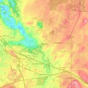
Nombre: Mapa topográfico Penfield, altitud, relieve.
Altitud media: 137 m
Altitud mínima: 72 m
Altitud máxima: 182 m
Haz una donación
Equípate para tu próxima aventura:
Como asociado de Amazon, este sitio gana comisiones por las compras que califican, sin ningún costo adicional para usted.