
Mapa topográfico Klosterwappen
Mapa interactivo
Haga clic en el mapa para ver la altitud.
Klosterwappen
A rack-and-pinion railway, the Schneeberg Railway, now over 100 years old, climbs to a height of 1,800 m (5,900 ft), reducing the walk to the summit to an hour or two. There are also a number of other routes for walkers, including from the spa resort of Puchberg am Schneeberg to the east, or from the south, in Höllental. On the north side of the Schneeberg there is the Fadensteig as an ascent path. For experienced hikers, the path over the Fadensteig is worthwhile. The starting point of the Fadensteig is the Edelweißhütte on the Fadensattel at an altitude of 1,235 m.
Acerca de este mapa
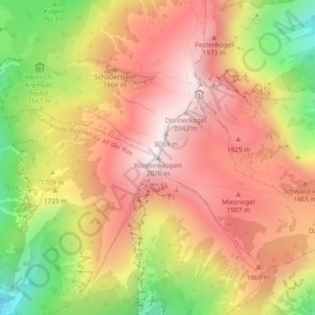
Nombre: Mapa topográfico Klosterwappen, altitud, relieve.
Altitud media: 1.715 m
Altitud mínima: 1.213 m
Altitud máxima: 2.068 m