
Haz una donación
Equípate para tu próxima aventura:
Como asociado de Amazon, este sitio gana comisiones por las compras que califican, sin ningún costo adicional para usted.
Mapa topográfico Glastonbury
Haga clic en el mapa para ver la altitud.
Haz una donación
Equípate para tu próxima aventura:
Como asociado de Amazon, este sitio gana comisiones por las compras que califican, sin ningún costo adicional para usted.
Glastonbury
Glastonbury, Connecticut, features a diverse topography characterized by its location along the eastern banks of the Connecticut River, where the terrain begins at a low elevation near the river and gradually ascends into rolling hills. The town encompasses notable elevations such as Kongscut Mountain and Minnechaug Mountain, with peaks reaching around 800 feet. These higher areas provide scenic views of the Hartford skyline and are complemented by regions of dense woodlands, including the expansive Meshomasic State Forest, which is popular for outdoor activities like hiking and fishing.
Haz una donación
Equípate para tu próxima aventura:
Como asociado de Amazon, este sitio gana comisiones por las compras que califican, sin ningún costo adicional para usted.
Acerca de este mapa
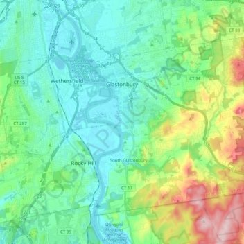
Nombre: Mapa topográfico Glastonbury, altitud, relieve.
Altitud media: 67 m
Altitud mínima: 0 m
Altitud máxima: 273 m
Haz una donación
Equípate para tu próxima aventura:
Como asociado de Amazon, este sitio gana comisiones por las compras que califican, sin ningún costo adicional para usted.
Otros mapas topográficos
Haga clic en un mapa para ver su topografía, su altitud y su relieve.
Willington Hill
United States > Connecticut > Capitol Planning Region > Willington
Altitud media: 197 m
Haz una donación
Equípate para tu próxima aventura:
Como asociado de Amazon, este sitio gana comisiones por las compras que califican, sin ningún costo adicional para usted.
Griswoldville
United States > Connecticut > Capitol Planning Region > Wethersfield
Altitud media: 34 m
Haz una donación
Equípate para tu próxima aventura:
Como asociado de Amazon, este sitio gana comisiones por las compras que califican, sin ningún costo adicional para usted.
Talcott Mountain
United States > Connecticut > Capitol Planning Region > Bloomfield
Altitud media: 152 m
Haz una donación
Equípate para tu próxima aventura:
Como asociado de Amazon, este sitio gana comisiones por las compras que califican, sin ningún costo adicional para usted.
South Wethersfield
United States > Connecticut > Capitol Planning Region > Wethersfield > Griswoldville
Altitud media: 22 m
Haz una donación
Equípate para tu próxima aventura:
Como asociado de Amazon, este sitio gana comisiones por las compras que califican, sin ningún costo adicional para usted.
Bishop's Corner
United States > Connecticut > Capitol Planning Region > West Hartford
Altitud media: 47 m
Talcott Mountain
United States > Connecticut > Capitol Planning Region > Bloomfield
Altitud media: 152 m
Johnson Hill
United States > Connecticut > Capitol Planning Region > West Hartford
Altitud media: 34 m
Haz una donación
Equípate para tu próxima aventura:
Como asociado de Amazon, este sitio gana comisiones por las compras que califican, sin ningún costo adicional para usted.
Haz una donación
Equípate para tu próxima aventura:
Como asociado de Amazon, este sitio gana comisiones por las compras que califican, sin ningún costo adicional para usted.
Holcomb Farm
United States > Connecticut > Capitol Planning Region > Granby > West Granby
Altitud media: 116 m
Haz una donación
Equípate para tu próxima aventura:
Como asociado de Amazon, este sitio gana comisiones por las compras que califican, sin ningún costo adicional para usted.
Stafford Springs
United States > Connecticut > Capitol Planning Region > Stafford
Altitud media: 200 m
Haz una donación
Equípate para tu próxima aventura:
Como asociado de Amazon, este sitio gana comisiones por las compras que califican, sin ningún costo adicional para usted.
Barbara Drive
United States > Connecticut > Capitol Planning Region > Windsor Locks
Altitud media: 39 m
Haz una donación
Equípate para tu próxima aventura:
Como asociado de Amazon, este sitio gana comisiones por las compras que califican, sin ningún costo adicional para usted.