

Mapa topográfico Posina
Haga clic en el mapa para ver la altitud.
Posina
Posina is a town in the province of Vicenza, Veneto, Italy. It is northeast of SS46. As of 2007 Posina had an estimated population of 657. Posina lies at an elevation of 600 metres (2,000 ft) at the foot of Mount Majo and Mount Gamonda, Mount Pasubio. On the whole dominates the Pasubio which can be accessed through the picturesque Val Caprara, Val Sorapache or arrived at passo Xomo on the Strada degli Scarubbi or the famous Strada delle 52 gallerie great work of military engineering the First World War.
Acerca de este mapa
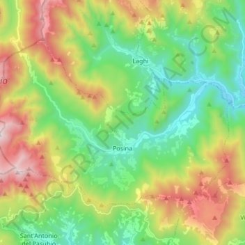
Nombre: Mapa topográfico Posina, altitud, relieve.
Lugar: Posina, Vicenza, Veneto, 36010, Italy (45.76878 11.18909 45.83300 11.32248)
Altitud media: 996 m
Altitud mínima: 403 m
Altitud máxima: 2.051 m
Otros mapas topográficos
Haga clic en un mapa para ver su topografía, su altitud y su relieve.


Cima Portule
Italy > Veneto > Vicenza > Asiago
Cima Portule is a mountain in Italy, located in the province of Vicenza in the Veneto region. It has an elevation of 2,308 metres (7,572 ft).
Altitud media: 1.938 m

Monte Cengio
Italy > Veneto > Vicenza > Cogollo del Cengio
Monte Cengio is a mountain in the Asiago plateau, within the Vicentine Alps, in Veneto, northeastern Italy. It has an elevation of 1,354 metres and is located on the southwestern edge of the plateau, in the territory of Cogollo del Cengio.
Altitud media: 935 m

Cima Dodici (Ferozzo)
Italy > Veneto > Vicenza > Asiago
Cima Dodici (Italian for "peak 12", in Cimbrian language Freyjoch) is a mountain on the border of Vicenza in Veneto and Trentino in Trentino Alto Adige, northern Italy, south of the village of Borgo Valsugana. It has an elevation of 2,336 metres. and is the highest peak in Vicenza. At 1,874 m prominence, it is…
Altitud media: 1.899 m




Monte Cengio
Italy > Veneto > Vicenza > Cogollo del Cengio
Monte Cengio is a mountain in the Asiago plateau, within the Vicentine Alps, in Veneto, northeastern Italy. It has an elevation of 1,354 metres and is located on the southwestern edge of the plateau, in the territory of Cogollo del Cengio.
Altitud media: 935 m


