
Mapa topográfico Plymouth
Haga clic en el mapa para ver la altitud.
Plymouth
The River Plym, which flows off Dartmoor to the north-east, forms a smaller estuary to the east of the city called Cattewater. Plymouth Sound is protected from the sea by the Plymouth Breakwater, in use since 1814. In the Sound is Drake's Island which is seen from Plymouth Hoe, a flat public area on top of limestone cliffs. The Unitary Authority of Plymouth is 79.83 square kilometres (30.82 sq mi). The topography rises from sea level to a height, at Roborough, of about 509 feet (155 m) above Ordnance Datum (AOD).
Acerca de este mapa
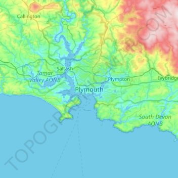
Nombre: Mapa topográfico Plymouth, altitud, relieve.
Altitud media: 81 m
Altitud mínima: -3 m
Altitud máxima: 512 m