
Haz una donación
Equípate para tu próxima aventura:
Como asociado de Amazon, este sitio gana comisiones por las compras que califican, sin ningún costo adicional para usted.
Mapa topográfico Dease Lake
Haga clic en el mapa para ver la altitud.
Haz una donación
Equípate para tu próxima aventura:
Como asociado de Amazon, este sitio gana comisiones por las compras que califican, sin ningún costo adicional para usted.
Dease Lake
Dease Lake has a subarctic climate (Köppen Dfc), typical of northern British Columbia. Summers are mild, coupled with chilly nights while winters are severely cold and snowy, with annual snowfall averaging 212.8 cm (83.78 in). Autumn typically begins by early September and lasts into October when winter begins. Winter can last into late March or sometimes early April. Spring usually lasts until late May or early June, after when summer begins. Due to Dease Lake's high elevation, snowfall is possible during any month of the year.
Haz una donación
Equípate para tu próxima aventura:
Como asociado de Amazon, este sitio gana comisiones por las compras que califican, sin ningún costo adicional para usted.
Acerca de este mapa
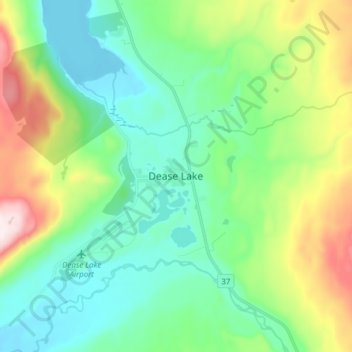
Nombre: Mapa topográfico Dease Lake, altitud, relieve.
Altitud media: 898 m
Altitud mínima: 750 m
Altitud máxima: 1.288 m
Haz una donación
Equípate para tu próxima aventura:
Como asociado de Amazon, este sitio gana comisiones por las compras que califican, sin ningún costo adicional para usted.
Otros mapas topográficos
Haga clic en un mapa para ver su topografía, su altitud y su relieve.
Beaver Lake
Canada > British Columbia > Regional District of Kitimat-Stikine > Area F (Dease Lake) > Dease Lake
Altitud media: 865 m
Dease Lake
Canada > British Columbia > Regional District of Kitimat-Stikine > Area F (Dease Lake)
Altitud media: 1.128 m
Ball Creek
Canada > British Columbia > Regional District of Kitimat-Stikine > Area F (Dease Lake)
Altitud media: 1.267 m
Sixteen Mile Creek
Canada > British Columbia > Regional District of Kitimat-Stikine > Area F (Dease Lake)
Altitud media: 1.267 m
Haz una donación
Equípate para tu próxima aventura:
Como asociado de Amazon, este sitio gana comisiones por las compras que califican, sin ningún costo adicional para usted.