
Mapa topográfico Renfrewshire
Mapa interactivo
Haga clic en el mapa para ver la altitud.
Acerca de este mapa
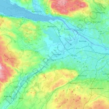
Nombre: Mapa topográfico Renfrewshire, altitud, relieve.
Lugar: Renfrewshire, Schotland, VK (55.75952 -4.78401 55.93629 -4.35311)
Altitud media: 104 m
Altitud mínima: -5 m
Altitud máxima: 435 m
Otros mapas topográficos
Haga clic en un mapa para ver su topografía, su altitud y su relieve.
Old Polmont
VK > Schotland > Old Polmont
Old Polmont, Falkirk, Schotland, FK2 0XZ, VK
Altitud media: 37 m
Greenbraehead
VK > Schotland > Greenbraehead
Greenbraehead, Scottish Borders, Schotland, TD9 9SW, VK
Altitud media: 187 m
Loch Lubnaig
VK > Schotland > Ardchullarie More
Loch Lubnaig, A84, Ardchullarie More, Stirling, Schotland, FK17 8HF, VK
Altitud media: 382 m
Inverasdale
VK > Schotland > Inverasdale
Inverasdale, Highland, Schotland, IV22 2LW, VK
Altitud media: 54 m
Loch Lomond
Loch Lomond, A82, Tom Na Glas, Inverbeg, Argyll and Bute, Schotland, G83 8PD, VK
Altitud media: 240 m
Fort Augustus
VK > Schotland > Fort Augustus
Fort Augustus, Highland, Schotland, PH32 4AY, VK
Altitud media: 115 m