
Haz una donación
Equípate para tu próxima aventura:
Como asociado de Amazon, este sitio gana comisiones por las compras que califican, sin ningún costo adicional para usted.
Mapa topográfico Obergoms
Haga clic en el mapa para ver la altitud.
Haz una donación
Equípate para tu próxima aventura:
Como asociado de Amazon, este sitio gana comisiones por las compras que califican, sin ningún costo adicional para usted.
Obergoms
The next settlement up the Rhone valley is Obergesteln, which is located on a terminal moraine of the Rhone glacier in the Rhone valley, at an elevation of 1,353 m (4,439 ft). Obergesteln is overlooked by the mountains of the Sidelhorn, to the north, and the Pizzo Gallina, to the south.
Haz una donación
Equípate para tu próxima aventura:
Como asociado de Amazon, este sitio gana comisiones por las compras que califican, sin ningún costo adicional para usted.
Acerca de este mapa
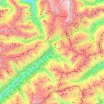
Nombre: Mapa topográfico Obergoms, altitud, relieve.
Lugar: Obergoms, Goms, Wallis, Switzerland (46.42362 8.25806 46.65405 8.47856)
Altitud media: 2.306 m
Altitud mínima: 1.068 m
Altitud máxima: 3.593 m
Haz una donación
Equípate para tu próxima aventura:
Como asociado de Amazon, este sitio gana comisiones por las compras que califican, sin ningún costo adicional para usted.
Otros mapas topográficos
Haga clic en un mapa para ver su topografía, su altitud y su relieve.
Grimselpass
Switzerland > Wallis > Goms > Obergoms
The Grimsel Pass (German: Grimselpass; French: Col du Grimsel; Italian: Passo del Grimsel) is a mountain pass in Switzerland, crossing the Bernese Alps at an elevation of 2,164 metres (7,100 ft). The pass connects the Haslital, the upper valley of the river Aare, with the upper valley of the Rhône. In so…
Altitud media: 2.154 m