
Haz una donación
Equípate para tu próxima aventura:
Como asociado de Amazon, este sitio gana comisiones por las compras que califican, sin ningún costo adicional para usted.
Mapa topográfico Fuhai
Haga clic en el mapa para ver la altitud.
Haz una donación
Equípate para tu próxima aventura:
Como asociado de Amazon, este sitio gana comisiones por las compras que califican, sin ningún costo adicional para usted.
Fuhai
The Altai Mountains traverses Fuhai County, and the two main rivers in the county are the Ulungu Lake and the Irtysh River. Ulungu Lake is located in Fuhai County. The county's elevation ranges from 386 to 3,332 m (1,266 to 10,932 ft), with an average elevation of about 500 m (1,640 ft).
Haz una donación
Equípate para tu próxima aventura:
Como asociado de Amazon, este sitio gana comisiones por las compras que califican, sin ningún costo adicional para usted.
Acerca de este mapa
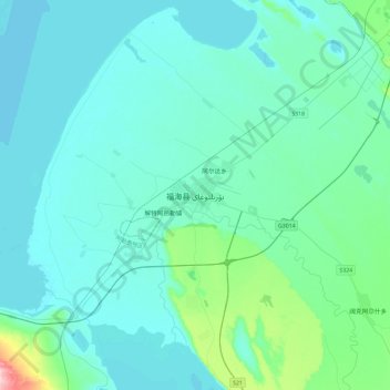
Nombre: Mapa topográfico Fuhai, altitud, relieve.
Lugar: Fuhai, Fuhai County, Altay Prefecture, Xinjiang, 836400, China (46.95149 87.32375 47.27149 87.64375)
Altitud media: 504 m
Altitud mínima: 479 m
Altitud máxima: 715 m
Haz una donación
Equípate para tu próxima aventura:
Como asociado de Amazon, este sitio gana comisiones por las compras que califican, sin ningún costo adicional para usted.