
Mapa topográfico Beaulieu
Mapa interactivo
Haga clic en el mapa para ver la altitud.
Acerca de este mapa
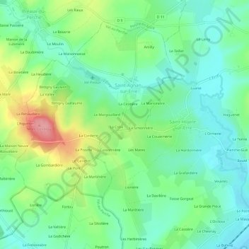
Nombre: Mapa topográfico Beaulieu, altitud, relieve.
Altitud media: 132 m
Altitud mínima: 97 m
Altitud máxima: 205 m
Otros mapas topográficos
Haga clic en un mapa para ver su topografía, su altitud y su relieve.
Mâle
France > Normandie > Orne > Val-au-Perche
Mâle, Val-au-Perche, Mortagne-au-Perche, Orne, Normandie, France métropolitaine, 61260, France
Altitud media: 149 m
La Taille
France > Normandie > Orne > Val-au-Perche
La Taille, Le Theil, Val-au-Perche, Mortagne-au-Perche, Orne, Normandie, France métropolitaine, 61260, France
Altitud media: 123 m
Le Theil
France > Normandie > Orne > Val-au-Perche
Le Theil, Val-au-Perche, Mortagne-au-Perche, Orne, Normandie, France métropolitaine, 61260, France
Altitud media: 141 m
L'Hermitière
France > Normandie > Orne > Val-au-Perche
L'Hermitière, Val-au-Perche, Mortagne-au-Perche, Orne, Normandie, France métropolitaine, 61260, France
Altitud media: 156 m
Gémages
France > Normandie > Orne > Val-au-Perche
Gémages, Val-au-Perche, Mortagne-au-Perche, Orne, Normandie, France métropolitaine, 61130, France
Altitud media: 146 m
La Rouge
France > Normandie > Orne > Val-au-Perche
La Rouge, Val-au-Perche, Mortagne-au-Perche, Orne, Normandie, France métropolitaine, 61260, France
Altitud media: 127 m
La Monnerie
France > Normandie > Orne > Val-au-Perche
La Monnerie, Gémages, Val-au-Perche, Mortagne-au-Perche, Orne, Normandie, France métropolitaine, 61130, France
Altitud media: 137 m