
Mapa topográfico Millinocket
Mapa interactivo
Haga clic en el mapa para ver la altitud.
Acerca de este mapa
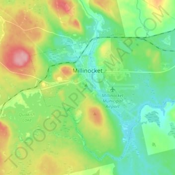
Nombre: Mapa topográfico Millinocket, altitud, relieve.
Lugar: Millinocket, Penobscot County, Maine, 04462, United States (45.61065 -68.75326 45.68671 -68.62147)
Altitud media: 140 m
Altitud mínima: 100 m
Altitud máxima: 218 m
The town is crossed by State Route 11 and State Route 157. The town of East Millinocket is located 8 miles (13 km) to the east. Millinocket is the closest town to Mount Katahdin, located in Baxter State Park 20 miles (32 km) to the northwest. At an elevation 5,270 feet (1,610 m), its summit is the highest point in Maine and the northern terminus of the Appalachian Trail.
Otros mapas topográficos
Haga clic en un mapa para ver su topografía, su altitud y su relieve.
Sugar Island
United States > Maine > Penobscot County > Greenbush
Sugar Island, Greenbush, Penobscot County, Maine, 04418, United States
Altitud media: 41 m
Lakeville
United States > Maine > Penobscot County
Lakeville, Penobscot County, Maine, United States
Altitud media: 138 m
Plymouth
United States > Maine > Penobscot County
Plymouth, Penobscot County, Maine, 04969, United States
Altitud media: 92 m
Tiger Rips
United States > Maine > Penobscot County
Tiger Rips, T6 R7 WELS, Penobscot County, Maine, United States
Altitud media: 226 m
Enfield
United States > Maine > Penobscot County
Enfield, Penobscot County, Maine, 04493, United States
Altitud media: 76 m
Passadumkeag
United States > Maine > Penobscot County
Passadumkeag, Penobscot County, Maine, 04475, United States
Altitud media: 51 m
Orono
United States > Maine > Penobscot County
Orono, Penobscot County, Maine, United States
Altitud media: 44 m
State Island
United States > Maine > Penobscot County
State Island, T2 R8 WELS, Penobscot County, Maine, United States
Altitud media: 147 m
Carmel
United States > Maine > Penobscot County
Carmel, Penobscot County, Maine, 04419, United States
Altitud media: 76 m
Burlington
United States > Maine > Penobscot County
Burlington, Penobscot County, Maine, 04417, United States
Altitud media: 108 m
Webster Plantation
United States > Maine > Penobscot County
Webster Plantation, Penobscot County, Maine, United States
Altitud media: 122 m
Bangor
United States > Maine > Penobscot County
Bangor, Penobscot County, Maine, 04401, United States
Altitud media: 42 m
Glenburn
United States > Maine > Penobscot County
Glenburn, Penobscot County, Maine, 04401, United States
Altitud media: 46 m
Howland
United States > Maine > Penobscot County
Howland, Penobscot County, Maine, 04448, United States
Altitud media: 62 m
Levant
United States > Maine > Penobscot County
Levant, Penobscot County, Maine, 04456, United States
Altitud media: 60 m
Lincoln
United States > Maine > Penobscot County > Lincoln
Lincoln, Penobscot County, Maine, 04457, United States
Altitud media: 83 m
Lee
United States > Maine > Penobscot County > Lee
Lee, Penobscot County, Maine, 04455, United States
Altitud media: 130 m
Eddington
United States > Maine > Penobscot County > Eddington
Eddington, Penobscot County, Maine, 04428, United States
Altitud media: 51 m